

Drone Survey & Mapping Imagery
Precision Aerial Data: Elevating Your Surveying and Mapping Projects


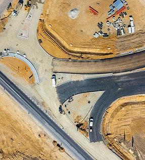
.jpg)
Benefits of Drone Imagery for Surveyors
Benefit 1: Accurate and Reliable Data
Our survey-grade imagery provides accurate and reliable data that meets the standards of certified surveyors. This allows you to make informed decisions with confidence and precision.
Benefit 2: Efficiency and Cost Savings
By utilizing drones for surveying and mapping, we offer faster data acquisition compared to traditional methods. This results in improved efficiency and cost savings for your projects, without compromising on data quality.
Benefit 3: Detailed and Comprehensive Analysis
The high-resolution imagery captured by our drones allows for detailed analysis and measurements. From topographic mapping and land surveys to infrastructure inspections and environmental assessments, our imagery provides the foundation for comprehensive analysis and decision-making.
Benefit 4: Customized Solutions
We understand that each project has unique requirements. Our team works closely with you to tailor our services to your specific needs, ensuring that we deliver the data and insights that are most valuable to your project.